
What Is 4D Imaging Radar?

adas

What Is 4D Imaging Radar?

What Is 4D Imaging Radar?

What Is 4D Imaging Radar?

4D imaging radar is high-resolution, long-range sensor technology that offers significant advantages over previous generations of radar. 

Originally developed to support adaptive cruise control and collision-mitigation systems, automotive radar has evolved into a critical component of ADAS. Advances in antenna design, signal processing and machine-learning techniques have enabled radar to move beyond basic object detection and contribute directly to scene understanding, environmental modeling and automated-driving functions. The same elements have also turned radar into an effective complement to cameras, lidar and other sensing technologies for AMRs and other autonomous devices requiring reliable perception across a wide range of operating conditions.

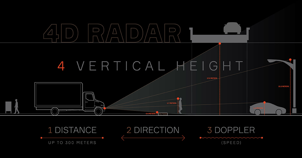
Radar’s most capable solution for automotive is 4D imaging radar, which provides precise measurements along four dimensions: an object’s range (distance), Doppler shift (from which relative velocity is derived), as well as azimuth angle (horizontal position) and elevation angle (vertical position).

Why is it called 4D?

Historically, automotive radar provided range, azimuth angle and relative velocity of an object. Today, the fourth dimension is elevation measurement and discrimination capability. These 4D radars are also capable of providing higher-resolution angle measurements (in both azimuth and elevation), providing a much richer dataset than 3D radar, which is why 4D is also known as “imaging radar.”

The ability to measure elevation is an important safety breakthrough. By enabling more detailed perception of the environment, including better object separation, it improves detection of roadside infrastructure, road edges and other features, as well as better identification of multiple objects in dense traffic conditions. As an example, a truck with 4D radar installed would be able to estimate the height of a tunnel’s ceiling, data that could be used to alert the driver not to enter. For another example, consider the challenge of over-drivability: quickly determining whether an object in the roadway should be avoided or can be safely driven over. The elevation information and improved object separation provided by 4D imaging radar can help differentiate a small piece of road debris from a larger object that may require evasive action.

How it works

A 4D imaging radar system consists of both data collection and data processing. To collect data, typical radar systems use an array of antenna elements, each with a wide beam. While a 3D radar system has antennas arrayed horizontally, 4D imaging radar systems use multiple transmit and receive antennas arranged in both horizontal and vertical dimensions. Through digital beamforming, they are combined to create an array of narrow beams, which improves the angular resolution of the resulting radar representation. Higher angular resolution enables the system to more accurately distinguish between nearby objects and determine their relative positions, improving object classification and tracking in complex driving environments.

Recent advances in radar processing can incorporate machine-learning techniques for object classification, trajectory prediction and environmental modeling. The result is a more accurate model capable of supporting increasingly sophisticated automated driving functions.

Even the most advanced 4D imaging radar doesn’t work in isolation, however. It is part of an integrated system of sensors that takes advantage of the strengths of each sensing modality. Because radar uses radio waves rather than visible light, it maintains strong performance in darkness, glare, rain, fog, snow and airborne particulates, providing a robust complement to the strengths of cameras. The two modalities can be combined through sensor fusion to create a cohesive, detailed picture of the vehicle’s surroundings, from infrastructure and roadway features to pedestrians, cyclists and other vehicles. Aptiv’s PULSE™ sensor achieves this in a compact format.

Beyond automotive applications, 4D imaging radar is emerging as an important sensing technology for robotics and autonomous systems. Its ability to generate robust environmental data while maintaining performance in adverse lighting and environmental conditions makes it well suited for AMRs, industrial automation, agricultural equipment and logistics platforms. In such situations, it can serve as both complement and cost-effective alternative to the traditional use of lidar or stereo cameras.

LEARN MORE ABOUT MACHINE LEARNING IN OUR WHITE PAPER

This article has been updated. It was originally published in 2021.
What Is 4D Imaging Radar?

4D imaging radar is high-resolution, long-range sensor technology that offers significant advantages over previous generations of radar. 

Originally developed to support adaptive cruise control and collision-mitigation systems, automotive radar has evolved into a critical component of ADAS. Advances in antenna design, signal processing and machine-learning techniques have enabled radar to move beyond basic object detection and contribute directly to scene understanding, environmental modeling and automated-driving functions. The same elements have also turned radar into an effective complement to cameras, lidar and other sensing technologies for AMRs and other autonomous devices requiring reliable perception across a wide range of operating conditions.

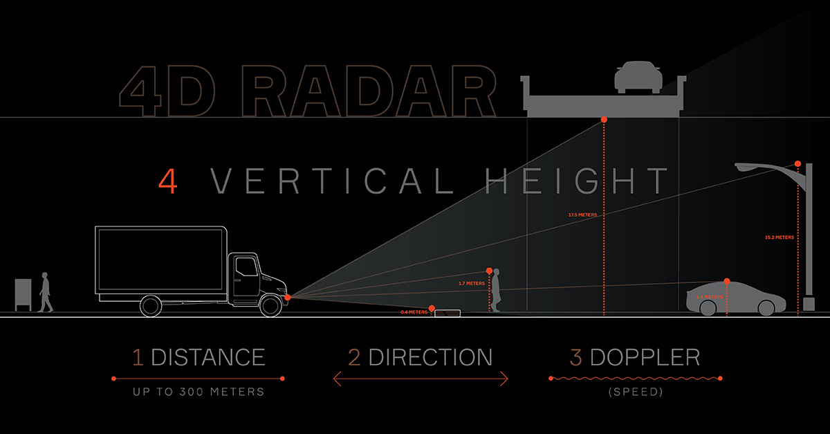
Radar’s most capable solution for automotive is 4D imaging radar, which provides precise measurements along four dimensions: an object’s range (distance), Doppler shift (from which relative velocity is derived), as well as azimuth angle (horizontal position) and elevation angle (vertical position).

Why is it called 4D?

Historically, automotive radar provided range, azimuth angle and relative velocity of an object. Today, the fourth dimension is elevation measurement and discrimination capability. These 4D radars are also capable of providing higher-resolution angle measurements (in both azimuth and elevation), providing a much richer dataset than 3D radar, which is why 4D is also known as “imaging radar.”

The ability to measure elevation is an important safety breakthrough. By enabling more detailed perception of the environment, including better object separation, it improves detection of roadside infrastructure, road edges and other features, as well as better identification of multiple objects in dense traffic conditions. As an example, a truck with 4D radar installed would be able to estimate the height of a tunnel’s ceiling, data that could be used to alert the driver not to enter. For another example, consider the challenge of over-drivability: quickly determining whether an object in the roadway should be avoided or can be safely driven over. The elevation information and improved object separation provided by 4D imaging radar can help differentiate a small piece of road debris from a larger object that may require evasive action.

How it works

A 4D imaging radar system consists of both data collection and data processing. To collect data, typical radar systems use an array of antenna elements, each with a wide beam. While a 3D radar system has antennas arrayed horizontally, 4D imaging radar systems use multiple transmit and receive antennas arranged in both horizontal and vertical dimensions. Through digital beamforming, they are combined to create an array of narrow beams, which improves the angular resolution of the resulting radar representation. Higher angular resolution enables the system to more accurately distinguish between nearby objects and determine their relative positions, improving object classification and tracking in complex driving environments.

Recent advances in radar processing can incorporate machine-learning techniques for object classification, trajectory prediction and environmental modeling. The result is a more accurate model capable of supporting increasingly sophisticated automated driving functions.

Even the most advanced 4D imaging radar doesn’t work in isolation, however. It is part of an integrated system of sensors that takes advantage of the strengths of each sensing modality. Because radar uses radio waves rather than visible light, it maintains strong performance in darkness, glare, rain, fog, snow and airborne particulates, providing a robust complement to the strengths of cameras. The two modalities can be combined through sensor fusion to create a cohesive, detailed picture of the vehicle’s surroundings, from infrastructure and roadway features to pedestrians, cyclists and other vehicles. Aptiv’s PULSE™ sensor achieves this in a compact format.

Beyond automotive applications, 4D imaging radar is emerging as an important sensing technology for robotics and autonomous systems. Its ability to generate robust environmental data while maintaining performance in adverse lighting and environmental conditions makes it well suited for AMRs, industrial automation, agricultural equipment and logistics platforms. In such situations, it can serve as both complement and cost-effective alternative to the traditional use of lidar or stereo cameras.

LEARN MORE ABOUT MACHINE LEARNING IN OUR WHITE PAPER

This article has been updated. It was originally published in 2021.
How helpful was this article?
i


×

Please let us know how helpful this article was, so we can provide you with the best content possible. If you have more feedback to share, please feel free to contact us.
Thank you!

Careers


Shape the future of mobility. Join our team to help create vehicles that are safer, greener and more connected.

View Related Jobs
All Attachments (1)